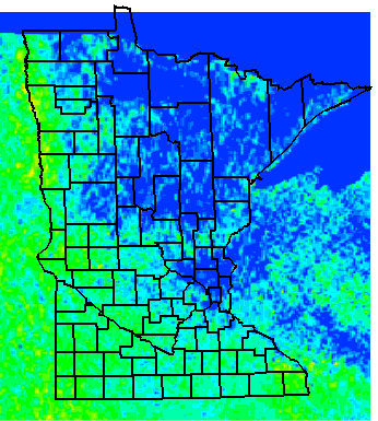
This map was extracted from the US. Geological Survey Digital Series DDS-9 CD-ROM (Phillips, J.D.; Duval, J.S.; Ambroziak, R.A. National Geophysical Data Grids: Gamma-Ray, Gravity, Magnetic, and Topographic Data for the Conterminous United States. US. Geological Survey Digital Series DDS-9; 1993). The primary measurements were taken as part of the NURE (National Uranium Resource Evaluation) project of the USDOE. Aerial gamma-ray surveys were conducted along east-west grid lines separated by 3 to 6 miles over most of the conterminous US. The observed flux of the 214 Bi line at 1764 keV is interpreted to yield an equilibrium equivalent 238 U content in parts per million (ppm eU).

Questions/Comments, e-mail: Dr. Steck
Last revised : 30 June, 2004
Visitor
since
06/30/04
Disclaimer
The views and opinions expressed on the web sites hosted on this server are strictly those
of the author.
The contents of the web sites on this server have not been reviewed or
approved by the College of St. Benedict|St. John's University.