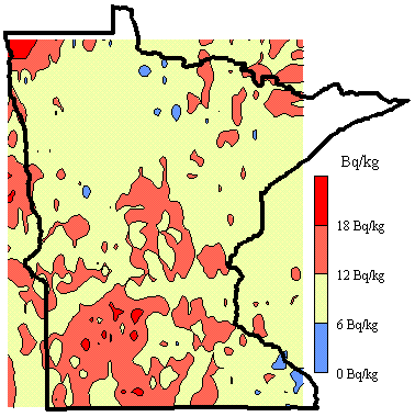
The radon generating potential of the soil at a location can be estimated from the surface gamma ray flux of the 1764 keV line of 214Bi, a radon decay product. This spectral line has been used before in a number of studies to estimate the near-surface radon concentration in the soil. For example the nationwide aerial survey conducted as part of the NURE project ( see NURE eU map) has been used by the USGS/EPA to help construct a national map of radon zones ( EPA Rn map). Since we are interested in characterizing surface radon concentrations near houses, our spatial sampling is not uniform nor comprehensive on a statewide scale as the NURE data. However it better samples the radon potential near population centers. We sample along highways and town streets. We developed a carborne system for mapping gamma radiation from soil located next to streets and highways ( Steck, 1993). The radionuclide concentrations were extracted from gamma ray spectra taken by a 7.6 x 7.6 cm NaI detector shielded to view the about 0.3 hectares of surface approximately 10 m beyond the right hand side of the automobile. Spectra were automatically acquired and analyzed by a onboard multichannel analyzer that was driven by batching software. Locations were determined every 40s by a global position receiver coupled to the portable computer. The flux is integrated during for 120 s. Spatial intervals cover 2 km along major highways, 1 km along county roads, and 0.4 km along city streets. By restricting data acquisition to times of stable weather, the 214Bi concentrations are reproducible to within 30%.

Questions/Comments, e-mail: Dr. Steck
Last revised : 30 June, 2004
Visitor
since
06/30/04
Disclaimer
The views and opinions expressed on the web sites hosted on this server are strictly those
of the author.
The contents of the web sites on this server have not been reviewed or
approved by the College of St. Benedict|St. John's University.